Posts

Showing posts from August, 2020

MOST DANGEROUS LIZARS

  MOST DANGEROUS LIZARS Lizards are a diverse group of reptiles that belong to the order Squamata, which also includes snakes. They have scaly skin, four legs (except for some legless species), movable eyelids, and external ear openings. They are mostly carnivorous and have various adaptations to avoid predators, such as venom, camouflage, and tail regeneration. There are more than 7,000 species of lizards in the world, living in different habitats and climates. Some of the most well-known lizards are the Komodo dragon, the chameleon, the gecko, and the iguana. Lizards are not dangerous to humans, however, some lizards are poisonous and can harm a person if they are touched or bitten by these reptiles. Certain lizards, such as the Komodo dragon, can grow to large sizes and have been known to attack and kill people. Most lizards, in reality, are harmless to humans, as are most turtles; however, there are certain members of both groups that can kill, maim, make ill, or inflict at...

PEECHI-VAZHANI WILDLIFE SANCTUARY

Image
  PEECHI-VAZHANI WILDLIFE SANCTUARY GENERAL INFORMATION Peechi-Vazhani Wildlife Sanctuary lies within the geographical extremes of  latitudes 10 0 26'N and 10 0 40'N and longitudes 76 0 15'E and 76 0 28'E in Thrissur District, Kerala State, in the Taluks of Thrissur and Thalappilly and in the administrative Jurisdiction of Northern Wildlife Circle, Palakkad. It was formed by combining portions of Peechi, Pattikkad and Machad Ranges of Thrissur Forest Division vide GO (M.S)No.871 dated 06,08.1958. The Sanctuary comprises of parts of Paravattani, Machadmala and Bharani Pachamala Reserves. The total area of the Sanctuary is 125 Sq km. The sanctuary area is the catchment of Peechi and Vazhani Reservoirs. Drinking water to Thrissur town is provided from Peechi Reservoir and water for irrigation purposes are provided from both Peechi and Vazhani Reservoirs HISTORY Till the dawn of 19th century the Forests of this sanctuary were under the poss...

KURINJIMALA SANCTUARY

Image
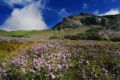
  KURINJIMALA SANCTUARY HISTORY OF KURINJIMALA SANCTUARY Kurinjimala Sanctuary is located on the eastern part of Southern Western Ghats of Kerala. The sanctuary is near Vattavada, about 42 Kms from Munnar town. Government of Kerala declared Kurinjimala Sanctuary on 6 th October  2006. The area has great ecological, founal, floral, geographical and zoological significance. The vegetation consists mostly of Shola and grasslands. Evergreen and deciduous forests are also found in the lower altitudes of the sanctuary, spread over Vattavada and Kottakamboor villages having an extent of 32 Sq. Km. The area is the natural habitat of Neelakurinji ( Strobilanthes kunthiana ) which blooms once in 12 years. The sanctuary also connects Chinnar Wildlife Sanctuary, Anamudi Shola National Park and Pampadum Shola National Park.   The sanctuary ensures the long term protection of the unique bio-diversity of the especially Stobilanthes kunthiana and its habitat. The sanctuary ...

SHENDURNEY WILDLIFE SANCTUARY

Image
  SHENDURNEY WILDLIFE SANCTUARY GENERAL INFORMATION Shendurney Wildlife Sanctuary, part of Agasthyamala Biosphere Reserve owes its name to the endemic species, Gluta travancorica , locally known as "Chenkurinji". The sanctuary was established in  1984 and lies on the western part of Agasthyamala Ashambu hill range with an altitudinal span of 92 m to 1950 m. Shendurney valley and the catchment of Kallada Irrigation Project fall within the boundaries of this protected area. The drainage comprises the major rivers Shendurney, Kazhuthurutty and Kulathupuzha which together join to form the Kallada river and the major tributaries are Parappar, Uruliyar, Pasmakandamthodu, Aruviar and Umayar. HISTORY The tract dealt with in this report is exclusively the property of the State Government of Kerala. This Sanctuary consists of only a portion of Kulathupuzha Reserve Forests. In exercise of the powers conferred by subsection (1) of Section 18 of the Wildlife (Protectio...

PERIYAR TIGER RESERVE

Image
  PERIYAR TIGER RESERVE GENERAL INFORMATION ABOUT  PERIYAR TIGER RESERVE Periyar Tiger Reserve is nestled in the Southern Western Ghats mountain ranges of peninsular India. Predominately an evergreen biotope with great scenic beauty, religio-cultural heritage and rich assemblage of Flora and Fauna. Periyar Tiger Reserve owes its name to the Periyar River which originate from the forest track of the mountain Sprawled over an extent of  925 km2 of core area or critical Tiger Habitat, the Tiger Reserve epitomize unique ecological and cultural diversity of the rain forest. Because of its natural splender, Periyar is a popular destination for the thousands of tourists and nature lovers. Also the reserve harbors a variety of endangered and endemic species. Administratively, it falls in Idukki and Pathanamthitta Districts of Kerala HISTORY OF  PERIYAR TIGER RESERVE The present Periyar Wildlife Sanctuary was constituted in  1950  and was brought unde...

THATTEKAD BIRD SANCTUARY

Image
  THATTEKAD BIRD SANCTUARY GENERAL INFORMATION ABOUT THATTEKAD BIRD SANCTUARY Thattekad Bird sanctuary was formed in 1983. It’s first name was Salim Ali Bird Sanctuary. It was after the survey of the great ornithologist Dr. Salim Ali the avifaunal richness of this area was recognized. He has recorded 167 species of birds during his survey in 1930.   Thattekad is on the foothills of the Western Ghats and connects with large ecological units comprising of Malayattoor. Sholayar, Parambikulam hill ranges on the one sde and Munnar, Eravikulam and Chinnar on the other side which supports diverse vegetation types from evergreen to such forests. HISTORY OF THATTEKAD BIRD SANCTUARY Thattekad being the first forest area along the road connecting Kannan Devan Hills with Cochin, the Britishers started exploring this area in the 19th century itself. It was during  1930  when the great ornithologist Dr. Salim Ali during his avifaunal survey could r...

MATHIKETTAN SHOLA NATIONAL PARK

Image
  MATHIKETTAN SHOLA NATIONAL PARK   GENERAL INFORMATION ABOUT MATHIKETTAN SHOLA NATIONAL PARK      The Mathikettan Shola National Park falls in Idukki district in Udumbanchola Taluk of Poopara village with an extent of 1281.7419 hectares. Mathikettan Shola National Park is the abode of several endemic species of flora and fauna. The altitude ranges between 1200-1984 m. The elevation increases from west to east and the highest points is Kattumala, which is located in the eastern border of the Mathikettan Shola National Park adjoining Tamil Nadu. The forest is seen as a continuous patch from 1200m up to 1500m above which it is seen as small patches dispersed among the grasslands. The area is drained by Panniyar River. Southwest monsoon and North East monsoons are very rich in Mathikettan Shola National Park. The coldest months are December and January when the minimum temperature inside forests fall up to 9 C even at lowe...

ANAMUDI SHOLA NATIONAL PARK

Image
  ANAMUDI SHOLA NATIONAL PARK FORMATION OF ANAMUDI SHOLA NATIONAL PARK Anamudi Shola NATIONAL PARK   was declared as a National Park in December 2003 as per notification No:  12876 /F2/ 2003 /F &WLD dated 14.12.2003 of the Kerala Government. The Anamudi Shola National Park consists of three Shola Reserve Forests namely  Mannavan Shola, Pullambadi shola and Idivaru Shola together occupying an area of  42.68 Sq, Km). GENERAL INFORMATION ABOUT ANAMUDI SHOLA NATIONAL PARK The Anamudi Shola National Park is located in the Western Ghats. It lies just east of Eravikulam National Park, where precipitation is maximum and the rain clouds traveling further east becomes relatively barren which accounts for the lesser rainfall. The coldest months are December and January when the minimum temperature inside forests  fall up to 6° C even at lower elevations. The temperature varies with a minimum of 6° C (December) to a maximum of 30° C (Apr...

SILENT VALLEY NATIONAL PARK

Image
    SILENT VALLEY NATIONAL PARK   GENERAL INFORMATION   Silent Valley forests also known as Sairandhri Vanam are located at the south western corner of the nilgiris in the western ghats. The local name Sairandhri Vanam is mythologically linked with the character in the Mahabharata. It is believed that this name could have given rights to in a distorted form the present name silent valley. Another version of the story is that the later name owned its origin to the relative absence of the Cicada insects which normally cause a distinctive sound in the forest. Many years ago the people of this country fought a campaign to save Silent Valley form being submerged under the waters of the proposed hydel project. The international community of scientists and naturalists including IUCN and WWF had supported this popular movement. They had even initiated a legal battle before the Honourable High Court of Kerala. The legal battle was lost. Yet the Government of India a...